
Final Project
The sites I chose for my final riverscapes project were all located at distinct places along the Bear River.

Flow direction
The Bear River runs approximately 350 miles from its headwaters in the Uinta Mountains of northeast Utah through Wyoming, Idaho, and back into northern Utah where it eventually flows into the Great Salt Lake. The overall Bear River Basin has a temperate climate with hot summers and cold winters.

Laterally Unconfined
Partly Confined
Confined
Map built with USGS data; originally created by Wikipedia user Kmusser.
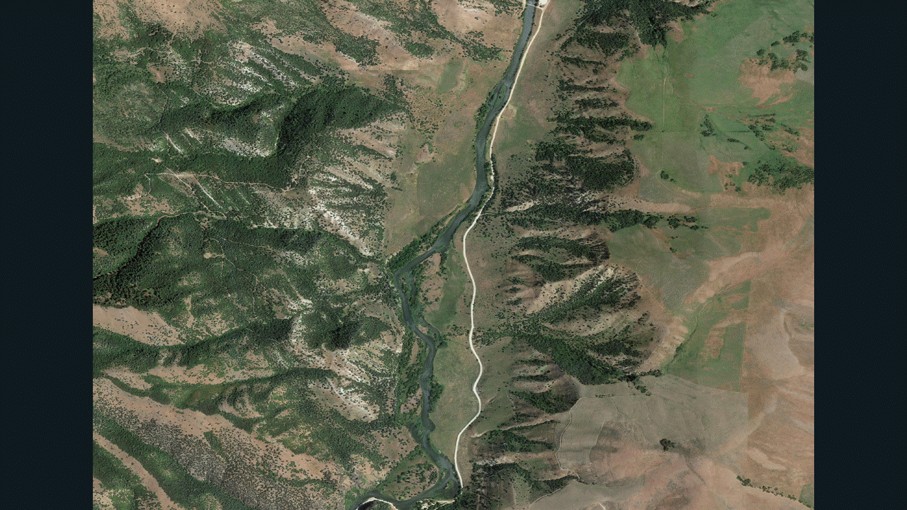
The River Style by Cutler Reservoir
Tier 1 Map


Quick Stats:
Located in the Malad & Cache Valley EPA Ecoregion characterized by warm summers and cold winters.
River runs through Pleistocene unconsolidated sedimentary rock; surrounded by sedimentary carbonate rock.
Low relative roughness due to low sediment supply to the river and a moderate grade due to anthropogenic channel bed modification as the river is more confined.
100% confined
99% constrained
1.35 mile length
Max riverscape width of 522 feet
Proportion of valley bottom channel: 99%
Proportion of valley bottom in active floodplain: 1%
Proportion of valley bottom inactive: 99% (See terrace for historical floodplain extent).
River Style: Entrenched Bedrock Canyon
The River Style Downstream of Oneida Narrows Reservoir

Photo Credit: American Whitewater

Photo Credit: BLM

Quick Stats:
Located in the Semiarid Hills & Low Mountain EPA Ecoregion characterized by warm, dry summers and cold winters.
River runs through Pleistocene unconsolidated igneous & sedimentary rock; eventually the river runs through carbonate rock further downstream.
Low-moderate relative roughness and varied grade. The channel's grade is lower when it is not in direct contact with confining margins but it steepens around the confining margin collision sections of the reach. Note that the geologic map has a mathematically derived stream path which doesn't line up with my hand-drawn channel margins.
25% confined.
40% constrained at confining margins. Lower area is much more flat and has less steep banks.
2.15 mile length
Max riverscape width of 435 feet
Proportion of valley bottom channel: 40%
Proportion of valley bottom in active floodplain: 80%
Proportion of valley bottom inactive: 20%
River Style: Low-Moderate Planform Controlled Discontinuous Floodplain
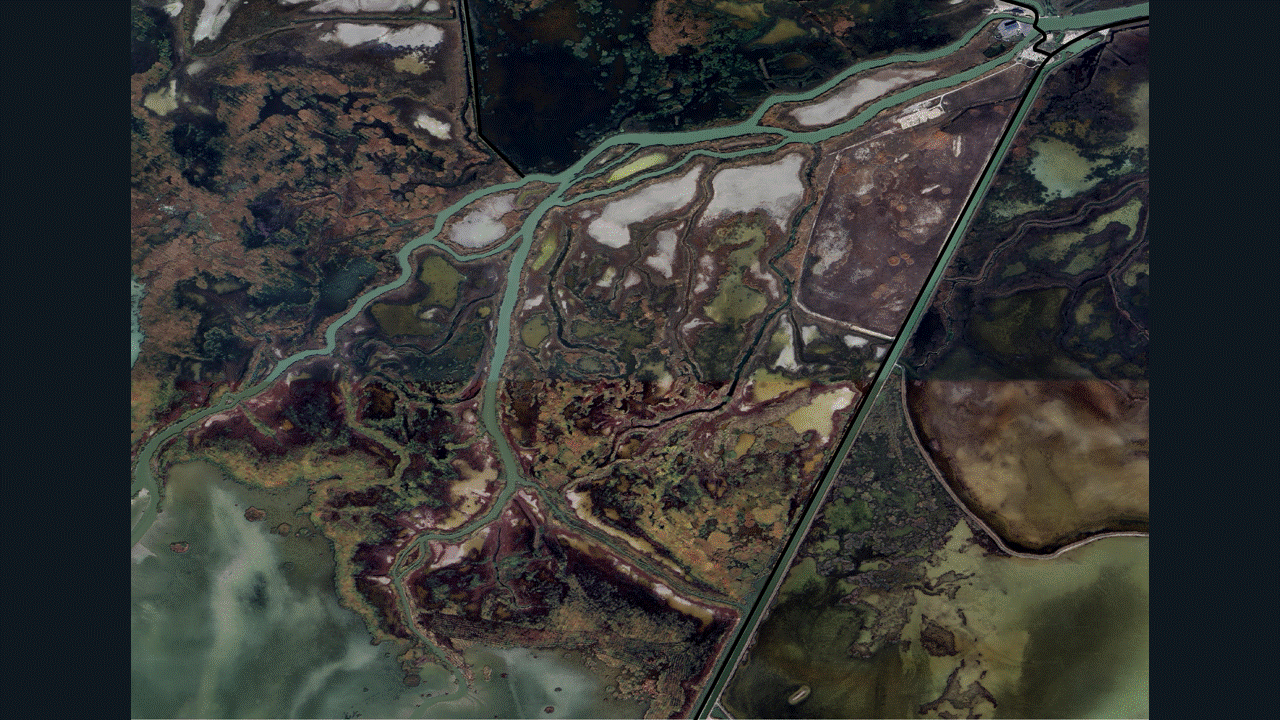
The River Style As The River Runs Into The South Bay

Photo Credit: Sandy Barson

Photo Credit: Nathan Pyper

Quick Stats:
Located in the Wetlands EPA Ecoregion characterized by large areas of floodplain inundation.
River runs through Holocene unconsolidated sedimentary rock as it flows into the South Bay.
Very low relative roughness and grade as the river is given plenty of room to meander within its valley bottom and floodplains.
0% confined.
0% constrained.
5.04 mile length
Max riverscape width of 3,595 feet
Proportion of valley bottom channel: 50%
Proportion of valley bottom in active floodplain: 95%
Proportion of valley bottom inactive: 5%
River Style: Meandering Fine Grain Bed River
Contrasting River Styles

When examining the 3 reaches of the Bear River seen above, the role of anthropogenic modification is the main geomorphic control that affects (or does not affect) each reach. The straightened confined and partly confined reaches of the river both have nearby dams or reservoirs; as such, their individual grade and freedom to laterally/vertically move are being constrained by human engineers to suit the needs of their adjacent dam/reservoir structures. An opposite situation exists at the laterally unconfined reach of the Bear where the river runs through a protected area of land (the Bear River Migratory Bird Refuge). The laterally unconfined river is running into a bay of open water instead of towards a dam or from a reservoir, so its grade is the lowest of all 3 and its sinuosity is the highest, followed by the partly confined and confined river reaches, respectively.
Because the river by the South Bay is unconfined, it also has a substantially greater access to its floodplain and many more geomorphic units such as floodplain islands, ponds, chutes, and diagonal bars have been able to be formed within its riverscape. On the contrary, the partly confined river still has some floodplain islands and point bars within its riverscape, but they are far less abundant than the South Bay adjacent river reach. The confined reach has the lowest amount of geomorphic units overall; really, it only has a single floodplain island which will eventually be eroded into the river over time. It should be noted as well that the South Bay adjacent Bear River reach has the greatest sediment supply since its floodplain connection is the highest, so its diversity of geomorphic units is further increased by this factor as well.
In summary, as you move from the top-most partly confined reach, down to the confined reach, and finally the most downstream laterally unconfined reach of the Bear River, the sediment supply, floodplain connection, lowering of the river grade, and the diversity of geomorphic units in the riverscape all increase as the level of confinement is decreased. The confined river reach has the least geomorphic unit diversity, lowest sediment supply, least accessible floodplain, and the steepest grade of the rivers; while the opposite is true for the laterally unconfined river.